Wednesday, October 19, 2016

How Did Recent Ice Ages Impact Brazil?

Previous Glacial Period


From 110,000 to 12,000 years ago, the Earth experienced the most recent glacial period. This time period was during the pleistocene epoch when ice covered a vast amount of the world. Large sheets of ice covered most of North America, northern Europe, and Asia. Parts of South America were also covered in large ice caps. Since the sea level was around 120 meters lower during the last glacial period than it is today, Brazil was affected by this ice age. The weight of the ice pushes down on the Earth's crust, which displaces the fluid mantle under the crust and causes a bulge. When that ice melts, then, the crust slowly returns back to its normal state. Since the entire world was affected by this period, it can be assumed that Brazil experienced some of this bulging and re-stabilizing. 


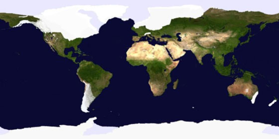
A map of the world during the last ice age. Notice the white ice caps extending up South America into Brazil. 

Ice Age Effects on South American Climate


Until recently, many researchers believed that South America, the continent in which Brazil lies, was dry and arid during the ice ages of the pleistocene epoch. Sediment core samples from Lake Titaca shows 25,000 years of precipitation records that may disprove the theory of dryness. Geologist Paul Baker and his colleagues took core samples, some up to 46 feet long, from the bottom of the lake. After analyzing the oxygen, magnetism, concentrations of calcium carbonate, and fossils of algae, the scientists concluded that the lake's surroundings were wet during the last Ice Age. Brazil, which neighbors both Peru and Bolivia where the lake lies, then, would have also had a wet climate during the last ice age. 

Lake Titaca which lies between the border of Peru and Bolivia. The lake is close to Brazil.


Sources

https://www.scientificamerican.com/article/ice-age-south-america-was/
http://bodaciousdreamexpeditions.com/fox-glacier-mega-magilla/
http://www.crystalinks.com/laketiticaca.html

Sunday, October 16, 2016

History of Brazil's Geography

Back in Time 

Brazil is entirely on the South American Platform- a portion of the South American plate that is continental. Evidence suggests the South American Plate broke from Pangea- the super-continent formed approximately 300 million years ago. The Nazca plate has been converging with the South American plate for the past 70 million years. This convergence partially led to the formation of the Andes- a massive mountain range in Brazil. Brazil became solid on the South American plate sometime in the Paleozoic period- the oldest era of the Proterozoic period.

The dark red section is Brazil which rests on the South American Plate 

Sources

http://www.brcactaceae.org/geology.html
https://www.britannica.com/science/Proterozoic-Eon
http://americastectonics.weebly.com/south-american-plate.html

Current Climate of Brazil

Perfect Vacation Spot

Because of Brazil's tropical location, the region is perfect for a warm vacation getaway. In the winter time, temperatures on average range from 55 to 64 degrees Fahrenheit, and the summer range is between 86 and 104 degrees Fahrenheit. Winter time is Brazil is three months long- June to August. Brazilian summer, on the other hand, is from December to February. Though the warm temperatures of the summer in Brazil are appealing, they come with frequent rainfall and a high humidity. 


The table above shows the average monthly temperatures in Brasilia, Brazil's capital, from 2010 to 2015.


Different Climate Conditions

Brazil is a massive country that houses various climate conditions. On the coast, it is hot and humid for most of the year, with a dryer season from March to November. Similarly, the Amazon jungle and surrounding areas are the hottest in the region, and have incredibly humid conditions. In the southern part of Brazil in the mountains, air temperatures can be a lot colder than the country's average, even dropping as low as 32 degrees Fahrenheit.


A rain forest in the Amazon Jungle where temperatures can reach up to 104 degrees Fahrenheit


Sources

http://www.worldtravelguide.net/brazil/weather-climate-geography
https://weather-and-climate.com/average-monthly-Rainfall-Temperature-Sunshine-in-Brazil
https://weather-and-climate.com/average-monthly-Rainfall-Temperature-Sunshine,Brasilia,Brazil
http://www.buzzle.com/articles/amazon-rainforest-facts.html

Sunday, September 25, 2016

Brazil's Physiography


The Cerrado Savanna in Brazil


General Information

Brazil is the fifth largest country in the world, with its coast stretching nearly 2,700 miles from North to South. The region has a wide range of landscapes such as plateaus, low mountains, savannas, and wetlands. In addition, Brazil is home to the majority of the world's largest river system-The Amazon River. This country is grouped into five geographical units called the Major Regions. These regions are: North, Northeast, Central West, Southeast, and South.

Brazil's Five Geographical Units

The North 

The North region of Brazil covers more than two-fifths of Brazilian territory. In addition, it contains the largest portion of the Amazon rainforest, as well as parts of the Guiana Highlands. The region, though, does not house much of the population, nor does it produce a lot economically.

The Northeast

Covering one-fifth of the Brazilian territory, cities in this region age back to 16th century. As well as being home to one-fourth of the population, this region accounts for one-fifth of the agricultural production. In addition, it experiences some of the nation's hottest and driest conditions.

The Southeast

Housing two-fifths of Brazil's population, the Southeast surprisingly only covers only one-tenth of Brazilian territory. Within this region is Minas Gerais- a landlocked state that is known for its mining, as well as the coastal state of Rio de Janeiro, the capital of the country.

The South

The South is the smallest of the five regions, and is agriculturally strong. Iguazu falls, which rests right on the Argentine Border. is responsible for the strong concentration of tourism in this region. This wonder stretches 2.7 kilometers, and is made of 275 waterfalls that, on average, pour 1,500 cubic meters of water every second.

The Central-West

Covering roughly one-fourth of Brazil, the Central-West includes forested valleys, wetlands, and semiarid highlands 

Outline of the five geographical units

Some Physical Features

Guiana Highlands

Residing in the North region, the Guiana Highlands is known for its vast forests, mountain ranges, waterfalls, and white-water rivers. The highest point of this area, the Neblina Peak along the Venezuelan border, is 9,888 feet. To the east of this peak is the Serra de Pacaraima, which is 9,094 feet at Mount Roraima.

Amazon Lowlands

The Amazon Lowlands are the widest lowlands along the the eastern base of the Andes. In these lowlands are hills called the terra firma, (solid ground,) that are made of layers of soil deposited millions of years ago that were uplifted. Low Oxbow lakes as well as wetlands are found here as well.

Pantanal

Pantanal is an extension of the Gran Chaco Plain and is a region of marshes and swamps. At 54,000 square miles, it is one of the largest freshwater wetlands in the world. Parts of the Paraguay River enter the Pantanal and overflow its banks during rainy seasons, causing floods.

This video shows stunning visuals of the Guiana Highlands, as well as provides more information on their creation and importance. 


Sources:

https://www.britannica.com/place/Brazil
http://www.cnn.com/2015/03/24/travel/iguazu-falls-bucket-list/
http://eddiebachoura.blogspot.com/2014/04/the-cerrado-savanna-in-brazil.html
https://upload.wikimedia.org/wikipedia/commons/4/47/Empire_of_brazil_frontiers_1889_(edit).png
https://www.youtube.com/watch?v=oy7ZneH94Jc

An Introduction to Brazilian Culture


The Brazilian Flag


Population, Religion, and Language

Similar to the United States, Brazil is a melting pot of different cultures and traditions. Of the over 200 million people in Brazil, around 50% are white individuals, 40% are mixed nationalities, and 10% are black. Interestingly, about 80% of the population is Roman Catholic as a result of Portuguese settlers building churches, and spreading the teachings of Catholicism to the tribes there. Also as a result of the Portuguese settlers in the 16th, 17th, and 18th centuries, the official language of the region is Portuguese with almost 100% of the region speaking it.

Family and Economics

Family is incredibly important to the people of Brazil. Families are usually large, and even extended family members are close with one another. The success of one's family economically often depends on their skin color. The wage gap in Brazil is quite evident, with the more successful people being those with lighter skin. In addition, women, who make up 40% of the Brazilian workforce, often do lower-paying jobs such as teaching and nursing, while men statistically make more money.


A map of Brazil issued by Portuguese Explorers in 1519


Sources:

http://www.commisceo-global.com/country-guides/brazil-guide
http://www.brazil.org.za/brazil-culture.html
http://www.hairottsalons.co.uk/wp-content/uploads/41206818_thumbnail.jpg
https://upload.wikimedia.org/wikipedia/commons/2/20/Brazil-16-map.jpg